Category Archives: Historic Sites

The Red Elm Cafe is a welcome addition

Red Elm Café at 1114 Martin Luther King Jr. Way, Tacoma WA 98405 opened in the early spring of 2017 and Monday, 7/3, I finally got to check it out. I had the chicken + Avo Sandwich ($5.25) and it was very tasty. My friend had a salad and Aussie Toast and both looked great, fresh, interesting and inexpensive! Dear friend and I sat side by side and talked about life and Office 365 (we are both in training). The Red Elm was a perfect spot to meet with a charming interior (I’m a sucker for exposed brick), free wifi and good food. Note to self, they have a private meeting room. My groups are always looking for a private meeting room! More information can be found on their website and Facebook page.

The Café is located in the Pochert Building, which is adjacent to the Kellogg Sicker building, (previously Browne’s Star Grill) which I noticed is also being renovated. A marvelous blog entry about both building can be found at the Historic Tacoma Blog.

This slideshow requires JavaScript.


Wapato Lake’s North Loop and Old Entrance

While walking our new pup around Wapato Lake in an effort to socialize him, I found one of the Park’s original entrances off of Wapato Lake Drive. Pup and I had taken the long way around the lake, crossing a narrow bridge and passing the largest field of cat tails that I’ve ever seen. We came out of the minor upper lake path to the site of two entry markers that said “Built by WPA”. The history of Wapato Lake is very interesting and can be found here.

Field of cattails

Lake Wapato

This use to be an entrance to Wapato Lake Park

The new dog, Rhody, a Norfolk Terrier

The narrow bridge on the north loop of Wapato Lake, Tacoma

The town of Moncton is Under Rattlesnake Lake


My friends and I had a meeting at the Cedar River Watershed Center in North Bend, King County recently and I was delighted to discover a teal colored Rattlesnake Lake. Random facts:

  • When the Masonry Dam was put into place 1915, it flooded Rainy Season Lake which became Rattlesnake Lake.
  • The small  town of Moncton was flooded by Rattlesnake Lake which was a surprise to the builders of the dam and to the residence of Moncton. There is a terrific slideshow of the town slowly flooding here.
  • There are no rattlesnakes near Rattlesnake Lake, in fact there are no rattlesnakes on this side of the Cascade Mountains.
  • Rattlesnake Lake and Rattlesnake Bluff got their names from the tall plants that had been plentiful in the area. When these plants dried, they had a rattle sound when in a breeze.
  • The color of the lake is because of the glaciers.
  • There is a top notch education center at the Cedar River Watershed and the meeting room was great too!
  • The green roof at the visitor’s center was so interesting.
  • It was raining, again. We have set all records for rain this year! (so, so tired of rain!)


A smooch on Grays River Covered Bridge

Sometimes it is good to have a small, doable goal. My goal of the day was to take a photo of every working covered bridge in Washington State. The Grays River Covered Bridge in western Wahkiakum County, Washington is Washington State’s only such bridge, though there are several others that are not operational or not public. This bridge was constructed in 1905 to facilitate the horse and wagon traffic of nearby farms. The cover was added in 1908 to protect the wood trusses. It was placed on the national registry of historic places in 1971 and the historic nomination form can be found here. Over the years, the bridge fell into disrepair and was renovated and reconstructed in 1988 and rededicated in 1989. The bridge span is 155.5 feet and the height of the bridge is 22.5 feet. The bridge is part of the Ahlberg Park which is the site of an annual covered bridge festival. A much better photo and more information can be found in the Wikipedia article. It was raining so hard and for so long that I just couldn’t bring myself to go out in the wet field for the photographic shot! Though I did include a bonus photo of a nearby barn!

Dear husband remembered the tradition of covered bridges being kissing bridges and claimed a kiss mid-span. It use to be, back in the day of wagons, that young folks would take advantage of the privacy of the covered bridges for a kiss or two.

It has been about 10 years since I’ve been on a covered bridge, with the last one being Emily’s Bridge in Vermont. Vermont wins the contest for the state with the most covered bridges. I actually have a photo of that Vermont bridge from ten years ago.

Emily’s Bridge


Lewis and Clark, End of the Trail in Seaside Oregon

The Lewis and Clark Expedition traveled 4,000 miles over 18 months to reach this place on the Pacific Ocean. This statue by Stanley Wanlass commemorates Lewis and Clark as well as Seaman, the Newfoundland dog that traveled with the expedition. At first I thought it odd that the statue faced away from most of the traffic, but of course it makes sense, Lewis and Clark are looking west!


It was our first time in Seaside Oregon and dear husband proclaimed it much like Atlantic City, NJ. Well, perhaps the Atlantic City years ago prior to gambling being legal there! The downtown area was full of stores, restaurants and hotels. Even the beach had a good number of folks on it, though they were sensibly wearing coats and rain gear. Mostly I just walked since I had our dog, Lilly, with me and she isn’t welcome in the establishments for the most part.


The Wreck of the Peter Iredale, Fort Stevens State Park


On October 25, 1906 the four-masted steel sailing vessel, the Peter Iredale, sank near the mouth of the Columbia River. No lives were lost. Dear husband and I had seen the ship before when we stayed at Fort Stevens State Park near Hammond, Oregon about 25 years ago. At that time we had our red chow, Yum, with us and we enjoyed the adventure of camping. And here I was years later with Lilly, our cairn terrier. I had dropped dear husband off at Astoria so that he could peruse the antique stores. There was less of the ship now, but still in all I was impressed that so much of it remained.

Graveyards of the Pacific lists some of the other ships that have gone down in this dangerous part of the Pacific.

While at Fort Stevens, Lilly and I also enjoyed two wildlife view areas, one with a boardwalk/concrete viewing area that overlooked an estuary and another with a viewing platform that overlooked the crashing waves of the Pacific. There is also the fort part of Fort Stevens State Park, which operated from the time of the Civil War through World War II. All of the photos are mine with the exception of the historical view of the ship.

This slideshow requires JavaScript.


Teapot Dome in Zillah, WA


image

In the early 1920s, during the presidency of Harding, our country was subject to the Teapot Dome Scandal, which revolved around oil reserves that were leased without competitive bid. There were two oil fields involved, the Teapot Dome fields in Wyoming and the Elk Hills field in California. The leases were investigated by the Senate and criminal charges were filed. Fines were paid, jail time served and the phrase Teapot Dome became synonymous with political corruption.

Well, in 1922, in the middle of the scandal, Jack Ainsworth, constructed his Teapot Dome Gas Station as a nod to the scandal. It is considered a roadside attraction and is open for visiting on the weekend for limited hours. Originally it was situated on Highway 410 between Zillah and Granger; however in 1978 it was scheduled to be moved to make way for Highway 82. Five days before it was to be moved, a car plowed into this tiny structure. The building, which is now on the historic register, was reconstructed by hand and moved to its current location at 14691 Yakima Valley Highway.  It has its own parking lot, a public restroom building and is next to a memorial for fallen firefighters.

I got there about five minutes before it closed (I didn’t even think it might be open!) and got the tour (about 2 minutes). The volunteers were delightful. I read that there is a movement to relocate the building once again to downtown Zillah and to have it function as a visitor’s center. I was glad to have a chance to see the quirky building, though the light made it difficult to capture the image.

This slideshow requires JavaScript.

The Dora Lee Langdon Cultural & Educational Center

imageIn an attempt to avoid the Texas heat, today I went to the Dora Lee Langdon Cultural & Educational Center is located at 308 East Pearl Street, Granbury, TX 76048 in the AP Gordon House. The art exhibit that brought me in was a solo exhibit of Gene Gregory and I enjoyed his vibrant paintings. The property was constructed as the Gordon house in 1882 and is actually smaller than it had originally been since the owners “downsized” by removing some of the back of the building in 1956.

image

image

image

image

A list of all the historic Granbury properties can be found here.

First National Bank, Granbury

image

Situated on Granbury’s Historic Square, the First National Bank (101 East Bridge Street) was constructed in 1883 and is an example of Italianate Victorian Commercial architecture.  The building was constructed for its current use and more of the history can be found here. The entirety of the Granbury Square is designated a historic district and was named the best historic square in Texas.

image

image

image

And while I was there I took a picture of the wonderful courthouse.

image

There was a famous aquarium at Salter’s Point

image

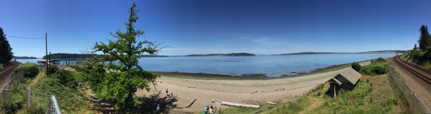
Dear daughter, her dear friend and I were looking for relieve from the heat on June 5 and we decided on a beach. Dear daughter suggested that beach where one goes on a footbridge over the railroad station. So after my online community and I figured out where that was, Salter’s Point at 91 Champion St. in Steilacoom, off we went. The footbridge is now a steep metal affair with gates on both sides of the stairs. It was constructed in 2014 after the prior wooden bridge was damaged and closed. About 60 trains a day pass along the tracks.

I was expecting to find some natural beauty, relief from the heat and perhaps a couple of small crabs. And indeed I found all that, but I also found an interesting history.

The covered picnic area built in 1939 as part of the Federal Works Progress Administration (WPA). Per Wikipedia the WPA “was the largest and most ambitious American New Deal agency, employing millions of unemployed people (mostly unskilled men) to carry out public works projects, including the construction of public buildings and roads. In a much smaller but more famous project, Federal Project Number One, the WPA employed musicians, artists, writers, actors and directors in large arts, drama, media, and literacy projects.”

The remains of a marina and store is located at the southerly end of the park. The property was destroyed by fire in 2009. The fire commanded the attention of three fireboats and more than 50 firefighters from eight fire departments. In 1987 there was a homicide at the store (Wang’s Maritime Marina); two teens killed the store’s owner. In close proximity to the marina ruins was the Soundview Inn and Boathouse, which was a boardinghouse with family style meals. They also had boat rentals.

The site of the Deep Sea Aquarium is also located at Salter’s Point. It was constructed by Ed Bair, brother of Bair (Bair Drugstore). The aquarium featured an extensive collection of sea life including a seal that lived under the porch where it could swim depending on the tide. The aquarium was promoted all over the western states, but closed in the 1930s.

Here are some interesting articles about the location.

A first person account about the aquarium 

“The evolution of Saltar’s Point,” Steilacoom Historical Museum Quarterly, XIV (Summer, 1985) p. l, 3-6.

City of Steilacoom Park Info

Fire destroys Steilacoom Marina and Store


This slideshow requires JavaScript.