Tag Archives: Bridge

Wapato Lake’s North Loop and Old Entrance

While walking our new pup around Wapato Lake in an effort to socialize him, I found one of the Park’s original entrances off of Wapato Lake Drive. Pup and I had taken the long way around the lake, crossing a narrow bridge and passing the largest field of cat tails that I’ve ever seen. We came out of the minor upper lake path to the site of two entry markers that said “Built by WPA”. The history of Wapato Lake is very interesting and can be found here.

Field of cattails

Lake Wapato

This use to be an entrance to Wapato Lake Park

The new dog, Rhody, a Norfolk Terrier

The narrow bridge on the north loop of Wapato Lake, Tacoma

Lincoln’s Eyes on the Skybridge

Finally I had a free day to snap a photo of the temporary art installation, Envision.  It is easy piece to miss, especially on a sunny day. It is located on the pedestrian bridge (skybridge) that connects two buildings (the Keystone Building and the Science Building) on the University of Washington, Tacoma campus. Envision is one of the installations that make up the Temporal Terminus: Marking the Line exhibit which is in place through the end of November. The project’s website states:

SITE 7: UW-T Pedestrian Bridge

Title: Envision
Artists: Jeremy Gregory, Diane Hansen, Ed Kroupa

Gigantic eyes look down on the campus from the pedestrian bridge. Are they benevolent? Visionary? Judging? That depends. The eyes are those of Abraham Lincoln, the visionary whose dream it was to complete a transcontinental rail that would meet the Pacific. Is he overlooking his accomplishment or wondering about this particular route’s demise and our crazy modern lives? Walking over the ped bridge, one experiences a different viewpoint and inspiration for the endurance of vision.

(Drat, I should have walked over the bridge!)

http://tacomaarts.wordpress.com/2011/11/10/prairie-line-trail-public-art-tour-draft/


Look here for more on the UWT campus. http://www.tacoma.washington.edu/shopuwt/docs/walking_tour.pdf

Update: October 2016. I finally crossed over on the sky bridge so here is an inside photo. Also a photo taken from above. 

Thinking about the proposed Tacoma Methanol Plant


I was standing in Fireman’s Park looking out over the Port of Tacoma wondering where the proposed methanol plant would be located. Once home I read that it is to be situated on the prior site of the Kaiser Aluminum Smelter on the Blair Waterway. So that would be on the far side of this photo, realistically out of sight. And I added the fog to the image for the drama.

This proposed plant would be the largest of its kind in the Pacific Northwest. Plants are also proposed to be located in the Port of Kalama, Washington and Port Westwood, Oregon. Tacoma’s plant could be operational as soon as 2020 and would produce 20,000 tons of Methanol daily. The Methanol would then be shipped to China.

I’m not going to offer an opinion before I know more, but I did find some interesting reading and sites.

I personally think we should all quickly study this issue and act accordingly. Our voices should be heard. To that end, there is a public meeting this Wednesday and it should be well worthwhile.

While I was there I photographed the classic mountain framed in the Murry Morgan Bridge and a lovely tree.

imageimage


The Puyallup River Bridge needs a home

imageThe Puyallup River Bridge isn’t over the Puyallup River. No that would be too easy. The steel tress bridge was built in 1925 and replaced in 2015 (90 years later). Now that the bridge has been relocated to an empty lot on the north side of Levee Road and the west side of Meridian (161) , the WSDOT is looking for to provide the bridge to another jurisdiction for different purpose such as a pedestrian or bicycle facility. If unsuccessful, WSDOT will recycle the steel. There is a marvelous time lapse video of the bridge being moved here.

My husband noticed the surplus bridge yesterday and just knew I’d like to see it. We parked right on the site and I walked along the side and for a short time underneath the structure.

This slideshow requires JavaScript.

Puyallup River Bridge

Bridge of Locks, University Place

IMG_1269A quick survey of my Facebook friends let me know that there are four Tacoma area bridges/overpasses that are being used as Bridge of Locks. On Sunday, which had glorious weather, I went to Bridge to the Beach that crosses the railroad tracks at Chambers Bay Regional Park in University Place. I hadn’t realized that I could drive down to the bottom of the park and I also didn’t know there was a bridge to the beach. What an amazing park it has turned into! There were families and couples with plenty of dogs. There were huge kites and picnics and music. Really it was splendid. I was there in August 2011 and it has significantly updated since then!

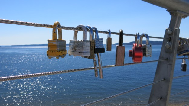
A short stroll took me to the modern bridge and at first I only saw a lock or two, but then there was a little cluster of them and at the end of the elevated pathway there were a number of them. Unlike many of the other Bridge of Locks, the arrangement of the Bridge to the Beach is such that each locks does not have its own little area, but instead can slide back and forth. This was a pretty exciting discovery for the four year old next to me!

Bridges of Locks are relatively new on a wide spread basis. The tradition is that those in love put their name on a lock then attach it to the bridge and throw the key away to symbolize their unfailing devotion.  This is a worldwide phenomena, as can be seen here.

The Bridges of Locks have not all been well received, with the weight of all those locks pulling down and damaging several structures. In University Place, there are no plans to remove the locks. Pierce County spokesman Hunter George said “We’re not encouraging it or discouraging it (the hanging of the locks). But we do think there are better ways. If people really want to demonstrate their commitment to each other, we’d love to see them get married at Chambers Bay. We have great rates. Or get a tattoo. Or both.”

Oh, and there is a picture of an osprey, just because they are such cool birds! Their wing span can be almost 6′ across, though I don’t know about the one on the nest.

This slideshow requires JavaScript.

Tacoma Avenue South Bridge

IMG_1223It seems like every time my family takes the Tacoma Avenue South Bridge, we wait for a traffic light. And if dear husband is in the car he starts griping about the bridge and how he hates it. He is convinced that it will go down in an earthquake. It’s to the point where even if he isn’t in the car, dear daughter and I will look at each other and say “I hate this bridge!”, but then we laugh.

It turns out dear husband is right (I hate when that happens!). According to a 5/25/13 article in the News Tribune, the Tacoma Avenue South over the NPRR (Northern Pacific Railroad) and South Tacoma Way has a sufficiency rating of 7. A rating of 100 means an entirely sufficient bridge, so 7 is really bad. In fact there is only one bridge in Pierce County that is worse and it is the SR 167 over the Puyallup River with a rating of 2. The Tacoma Avenue Bridge has two lanes and was constructed in 1930. It has a daily of over 10,000 vehicles.

Chris Larson, the city of Tacoma’s engineering division manager for public works, said the Tacoma Avenue South bridge will be closed for about 15 months starting in October 2014. The project is expected to cost $11.5 million, of which $11.2 million will come from state and federal grants.

IMG_1226

Read more here: http://www.thenewstribune.com/2014/07/11/3284880/demolition-of-pacific-avenue-bridge.html#storylink=cpy

Salmon Beach


10374461144_05be38c531_b(1) I’ve been wanting to visit Salmon Beach ever since I learned that there was a Salmon Beach! Friday night I was invited to a soiree at one of the cabins. It was great! Good friends and food, and an amazing view of the Tacoma Narrows and the Narrows Bridge. We even saw a seal 🙂

From what I’ve read, the community started as fishing shacks, but in 1934 electricity was brought in and the shacks became cottages. They are an eclectic collection of homes accessed by going down a long series of stairs (more than 200) and then a path.

My only regret is that I didn’t walk down to find the mermaid sculpture. Guess I’ll just have to go back!

To read more about the history of Salmon Beach try this link.

This slideshow requires JavaScript.


Gargoyle Bridge

9032286059_558bc90c59_b

Sunday dear husband and I went on the University Place Garden Tour and discovered a a gargoyle bridge at the end of Memory Lane West. It is a simple bridge over a ravine and along it to either side are gargoyles, one of which was shooting water out of his mouth. You have to look hard to see the gargoyles in the bridge photo, but they are there!The gargoyle artist also created a tranquil water scene.

The yard adjacent to the bridge had a miniature horse and a goat, as well as a chilled bag of carrots. They each got one from us 🙂

9112253381_6e521fcf99_b

9032274131_146e7e42cd_b 9001815278_daca2727c9_o

Feeding the Horse & Goat video. Click on the words.

43rd Street Bridge

The 43rd Street Bridge at 401 E 43rd St Tacoma Washington is very lovely. My family members actually found this bridge and pointed it out to me. I’ve been waiting for the trees to have some color before using it as my new place of the day. The bridge goes over a railroad track. The lead artists for lovely foliage mural are Chris Sharp and Kelda Martensen.